Common Practice: economic development in the post-Roman world
Today’s socio-economic challenges aren’t new. In the centuries after the retreat of the Roman state people with different backgrounds and with different ways of life somehow managed to build and maintain a complex economic system in northern Gaul.
By applying state of the art analytical models on available archaeological data, this research contributes to an understanding of how local communities in post-Roman northern Gaul organized their livelihoods. We will reconstruct the socio-economic functioning of northern Gaul in the period directly after the retreat of the Roman state.
Both the Roman and Carolingian periods are relatively well studied but the transformational Merovingian period between them, is poorly understood. This research will analyze livelihood strategies in 3 case studies and contribute to an understanding of local communities in post-Roman northern Gaul. The aim of this study is to provide fundamentals on what it exactly is that makes local economies resilient and successful.
Background
The early medieval ruling class wanted to present itself as an elite that was in control of things. However, an analysis into the livelihood strategies of ‘ordinary people’ is lacking. We don’t know how the main economic activities of the rural population were organized: either a livelihood of agriculture, pastoralism (livestock herding), horticulture or otherwise. The prevailing narrative of the early middle ages is largely based on later, Carolingian written sources. And is assuming an a priori economy based on agriculture.
Methods
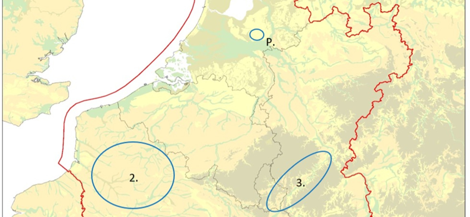
A regional geographic approach intrinsically brings together the social, economic and political spheres of everyday-life. The research will contribute to an understanding of the way different areas within northern Gaul were socio-economically organized and how these functioned as a region. New spatial analytical models will be developed for this purpose, that will incorporate anthropological and agronomical theory and will be applied on archaeological data from 3 diverse regions: the Dutch Friesland and Groningen provinces, the Picardy and the Moselle river valley (fig. 1). The assumption here is that, contra any physical determinism, the local environment doesn’t completely determine the way people live their lives, but it is an acknowledgement of the fact that geology, soil, hydrology and temperature do serve as a frame within which human activity will necessarily take place.

Figure 1. Simplified map of Northwest Europe as it was during the early middle ages, showing the research area (red polygon), case study areas (blue ellipses: 1, Marine and Coastal Landscapes; 2. Loess Plateaus; 3. Upland and Terraced Landscapes) and Preparatory study area (P. Coversand and Glacial Till Landscapes).
Partners
-
Research group Sustainable Areas and Soil Transitions, Saxion
- Faculty of Archaeology, Leiden University
Duration
2022-2027
Funding
Meer weten?
Wilt u meer informatie over dit project? Neem contact op:
